Wireless Access

last person joined: 23 hours ago 

Access network design for branch, remote, outdoor, and campus locations with HPE Aruba Networking access points and mobility controllers.
Expand all | Collapse all

VisualRF - Building Positioning

This thread has been viewed 3 times
  • 1.  VisualRF - Building Positioning

    Posted Oct 21, 2019 04:33 AM

    Hi All,


    So we have recently had airwave/visualRF installed into our system.


    I have been working through getting all buildings onto  VisualRF to help show the existing set-up and aid with future AP additions.


    However, while doing this I have run into a pretty terrible issue. The issue I have currently is that if there are 2 floors identical, when looking at bleed from above/below it doesn't seem to match up like the photo below. 


    To explain the example below, the Black Circle on the ground floor is the AP in its correct location, when looking at the floor above, the AP then becomes no where near where it should be, signified by the blue circle.


    I have looked into building orientation but as far as I can see, this didn't work as planned as I put in 2 gps coordinates and it messed with my scalings for the image completely, even then, this seems to only aid in positioning of APs on walls/ceilings (?). 


     I can't seem to find anything in any of their guides on how to help fix this. 


    I upload the site plans as .png and then add the boundaries walls etc. If there is another method better than this that will also allow for more accurate positioning, please let me know!


    Kind regards,

    Dipl0 
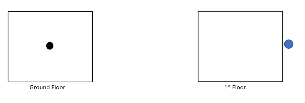
    AP Visual RF issue.PNG


  • 2.  RE: VisualRF - Building Positioning
    Best Answer

    Posted Oct 28, 2019 02:30 PM

    Try this. Go to one of your floors. On the right, click on Properties. Near the bottom click on measure. Now on your drawing, at a specifc point, click and hold and drag the line that appears to another point on your floorplan and let you. AirWave will display the distance that it thinks this is. If it is not correct, you can enter a new distance.


    Next, on the right click on View. Go down to the Floorplan Features section an click on Origin so that it has a check to the left of it. A red dot/circle will appear on your drawing. This is an alignment point. On each floor you will need to position this point so that the point is aligned between the floors. A corner of the building, stairwell, elevator shaft, are all good places to align the floors.


    At this point, the floor measurements will be accurate, and the floors will be aligned on each other.


    I hope this helps,


  • 3.  RE: VisualRF - Building Positioning

    Posted Oct 28, 2019 07:45 PM

    So if 'origin' is used for floor alignment, what is 'orientation' used for, and how is it used correctly? I had a similar problem where I attempted to set the orientation, and it distorted my whole map. I actually couldn't find a way to fix it and had to delete the whole floor and start over, and haven't touched orientation since. 


  • 4.  RE: VisualRF - Building Positioning

    Posted Oct 29, 2019 12:50 AM

    If it is where I think it is, you are selected on an AP. If an AP has external antennas, those antennas can be directional. As part of the placement/installation of a direction antenna, you need to know where the AP is aiming (orientation) along with the beamwidth of the RF signal. Technically when installing an AP you need to know the orientation/direction that the AP is aiming, along with any upward or downward tilt of the AP. VisualRF does not have the ability for you to enter the tilt, only the orientation, beamwidth, and antenna gain.


    I hope that helps,


  • 5.  RE: VisualRF - Building Positioning

    Posted Oct 29, 2019 03:06 PM

    No, this is a button for 'Edit Building Orientation'. When you click it, it has you click two GPS points on the map, then asks you to enter the LAT/LON for those two GPS points. It 'should' use that to orient the building (north/south, etc), but my experience is the same as the OP, it seems to mess things up more than it helps. 


    I'm also just starting to setup for NetInsight, and there are a few more details in the setup guide. They want you to set the Origin point for each floor to match the Lat/Lon set for the building to ensure proper location. So keep this in mind if you might start using NetInsight..


    Note: Being VRF complete helps make advanced Insights readily available and impactful.
    Building and Campus Locations are requested to be accurate geographically
    o NetInsight recommends using GIS Data for Building Lat/Lon and Rotations.
    o Please make sure the scaling factor is correctly handled. For example, if the buildings use
    mixed English and metric units, this may cause specific floors to extend beyond the expected
    size of the building.
    Should the LAT/LONG of the origin point of the building be same as Airwave?
    o Yes, please assign the lat/lon for the building to match the “origin” point for each floor of that
    building.
    Does NetInsight use the origin point as the South West corner of the building?
    o Without setting the origin, it defaults to the top-left corner of the floorplan.
    o It would be good to have the left edge of the VRF floorplan to point north


  • 6.  RE: VisualRF - Building Positioning

    Posted Nov 18, 2019 07:13 AM

    Perfect! 


    This was the solution, I've marked your response as the solution :) 


    Thanks for the help!


  • 7.  RE: VisualRF - Building Positioning

    Posted Nov 04, 2019 07:41 AM

    Sorry for the radio silence!


    I haven't had a chance to test this solution yet as, unfortunately, our airwave server seems to have keeled over and it's not having a good time.


    Once this is back up and running, I will test this out and update you on whether this is the solution or not!


    Kind regards,

    Dipl0